(the latest SWOT YouTube video, discussing river discharge estimation from SWOT)
The data are distributed through Hauteur des lacs et rivières – Data Terra | THEIA
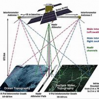
The SWOT (Surface Water and Ocean Topography) mission is a collaborative project between NASA, the French space agency CNES, the Canadian Space Agency, and the UK Space Agency. The satellite is designed to measure the height of the world's oceans, lakes, and rivers with unprecedented accuracy, providing valuable insights into the Earth's water cycle and the impacts of climate change.
Mission Objectives. The SWOT mission has several key objectives:
- Measure the height of the ocean surface with an accuracy of 2-3 cm
- Map the topography of the world's oceans, lakes, and rivers
- Study the dynamics of the ocean and its role in the Earth's climate system
- Provide data for improved weather forecasting, climate modeling, and water resource management
Instrumentation. The SWOT satellite is equipped with a state-of-the-art instrument called the Ka-band Radar Interferometer (KaRIn). This instrument uses radar pulses to measure the height of the water surface and create high-resolution maps of the ocean topography. The KaRIn instrument has a resolution of 50-100 meters, allowing for detailed mapping of coastal areas, rivers, and lakes.
Science Applications anc contributions. The data collected by the SWOT satellite will have numerous science applications, including:
- Studying ocean currents and circulation patterns
- Monitoring sea level rise and its impacts on coastal communities
- Improving our understanding of the global water cycle
- Enhancing climate modeling and prediction
- Supporting water resource management and conservation efforts
- Improved weather forecasting and warning systems for extreme weather events
- Enhanced climate modeling and prediction, allowing for better planning and decision-making
- Increased understanding of the impacts of climate change on coastal communities and ecosystems
- Improved management of water resources, supporting sustainable development and food security
Satellite Design and Launch. The SWOT satellite was launched in Dec 2022 on a SpaceX Falcon 9 rocket from Vandenberg Air Force Base in California. The satellite was placed in a sun-synchronous orbit, allowing for global coverage of the Earth's oceans and water bodies.
Data Products and Distribution. The SWOT satellite will produce a range of data products, including:
- Level 1 data: raw radar measurements
- Level 2 data: geolocated and calibrated data
- Level 3 data: science-quality data products, including ocean topography and water level maps. The data are distributed through Hauteur des lacs et rivières – Data Terra | THEIA, NASA's Physical Oceanography Distributed Active Archive Center (PODAAC) and other data portals.
In conclusion, the SWOT satellite is a groundbreaking mission that will revolutionize our understanding of the Earth's water cycle and the impacts of climate change. With its advanced instrumentation and global coverage, the SWOT satellite will provide valuable insights and data for scientists, policymakers, and stakeholders around the world.