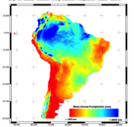
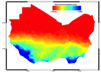
These are the “High-Resolution Precipitation Datasets” providing the mean annual precipitation for South America and West Africa. These datasets are available on a regular latitude/longitude grid with a spatial resolution of 1 km. They are based on well-established and long-standing precipitation datasets available in scientific literature at rough spatial resolution (ranging to 4 to 25 km), namely GPCC, TRMM 3B43, PERSIANN CDR, CHIRP, CMORPH, RainFall Estimator and TAMSAT. These datasets have been downscaled using a downscaling scheme that exploits the relationship among precipitation at rough spatial resolution, Digital Elevation Model and Enhanced Vegetation Index. For detailed information on the downscaling method and the datasets, please refer to our paper on the Remote Sensing website: http://www.mdpi.com/2072-4292/7/5/6454/html .
Why High-Resolution Precipitation Datasets in South America and West Africa?
Mean annual precipitation is one of the most important variables used in water resource management. However, quantifying mean annual precipitation at high spatial resolution, needed for advanced hydrological analysis, is challenging in developing countries which often present a sparse gauge network and a highly variable climate. In principle, satellites are accurate and versatile instruments to evaluate the precipitation instead, but their coarse spatial resolution (i.e., often in the region of 20 km) do not allow a direct use without undertaking the proposed downscaling.
Creators
Guido Ceccherini, Iban Ameztoy, Claudia Patricia Romero Hernández, Cesar Carmona Moreno and Andrea Iervolino.
Publication Year
2015
Spatial Coverage
South America: Latitude: 15.0 to -56.0; Longitude: -100.0 to -32.0
West Africa: Latitude: 30.0 to 0.0; Longitude: -18.0 to 17.0
Data Format
Zipped GeoTiff
Data Size
Around 50 Mbyte per file
Contact
Guido Ceccherini, Institute for Environment and Sustainability, DG Joint Research Centre, European Commission, Ispra 21027, Italy
Citations
To cite this dataset, please use:
Ceccherini, G.; Ameztoy, I.; Hernández, C.P.R.; Carmona-Moreno, C. High-Resolution Precipitation Datasets in South America and West Africa based on Satellite-Derived Rainfall, Enhanced Vegetation Index and Digital Elevation Model. Remote Sens. 2015, 7, 6454-6488.
See "High-Resolution Precipitation Datasets in South America and West Africa based on Satellite-Derived Rainfall, Enhanced Vegetation Index and Digital Elevation Model" for citations used in developing on the high resolution rainfall datasets.
| High Resolution Dataset |
GPCC |
TRMM 3B43 |
PERSIANN CDR |
CHIRP |
CMORPH |
RainFall Estimator |
TAMSAT |
|---|---|---|---|---|---|---|---|
 |
(99.5 Mb) |
(97.5 Mb) |
(98.4 Mb) |
(98.1 Mb) |
(99.9 Mb) |
||
 |
(31.5 Mb) |
(31.4 Mb) |
(24.3 Mb) |
(31.6 Mb) |
(31.8 Mb) |
(24 Mb) |
(23 Mb) |
Acknowledgements
The authors gratefully acknowledge support from JRC. This work was supported by EUROCLIMA and RALCEA projects, funded by European Commission EuropeAid Co-operation Office. The authors thank the providers of the dataset needed to perform this research. Rain gauge data for South America have been provided by: Jorge Núñez Cobo, Centro del Agua para Zonas Áridas y Semiáridas de América Latina y el Caribe (CAZALAC), Chile; Claudia Patricia Romero Hernández, Universidad Nacional, and Claudia Yaneth Contreras Trujillo, Instituto de Hidrología, Meteorología y Estudios Ambientales (IDEAM), Colombia; Arthur Lucas Bernardo, Laboratorio de Análise e Processamento de Imagens de Satélite (LAPIS), Brasil; Roberto Eduardo Zanvettor, Universidad Nacional de Córdoba (CREAN), Argentina; Franklin Javier Paredes Trejo and Freddy José La Cruz Alvaro, Centro de Investigaciones Hidrológicas y Ambientales (CIHAM-UC), Venezuela; Julia Acuña Azata, Servicio Nacional de Meteorología e Hidrología (SENAMHI), Perú. Rain gauge data for West Africa have been provided by: Sampson Oduro-Kwarteng, Kwame Nkrumah, University of Science and Technology, Ghana; Jacob Ehiorobo, University of Benin, Benin; Dogara Bashir and Martin Obada Eduvie, National Water Resources Institute, Nigeria; Alioune Kane, Awa Niang Fall, Université Cheikh Anta Diop de Dakar; Senegal. EVI 1 km resolution annual composites have been created using the method proposed by Tomislav Hengl at ISRIC (i.e., the World Soil Information Foundation).